강의

멘토링

로드맵

Inflearn brand logo image
Data Science

/

Data Analysis

QGIS Beginner All-in-One Starter Pack (Theory/Practice)

A theory-practice QGIS course covering analysis basics, advanced functions, and visualization introduction for QGIS utilization. Start QGIS by taking this unprecedented all-in-one course!!

(5.0) 22 reviews

113 learners

  • upwise
이론 실습 모두
데이터분석실습
gis
QGIS
GIS
data-analysis
data-visualization
spatial-data

Reviews from Early Learners

What you will learn!

  • GIS Basics and Theory

  • QGIS Vector/Raster/Data type Data Analysis

  • QGIS Vector/Raster Visualization

  • Analysis Process Practice Using Real Data

There has never been a QGIS course like this before 😲
All-in-one starter pack that teaches QGIS theory and practice in one lecture 🚀

#QGIS #GIS #data-analysis #data-visualization #spatial-data #GIS lecture #GIS education

This course is suitable for both beginners and users of QGIS.
You can learn basic GIS concepts and theories, QGIS analysis and visualization, and analysis methodologies applied to actual analysis processes.

Quickly improve your skills with this all-in-one QGIS course, the likes of which you've never seen before.

This QGIS lecture is divided into four major sections, and each section is organized in detail as follows.
[ GIS Basics and QGIS Basic Functions , Vector Layer Analysis and Visualization , Raster Layer Analysis and Visualization , 4 Practical Examples ]

Section Introduction

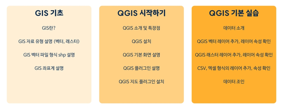
🟨 Section 1. GIS Basics and QGIS Basic Functions

Before starting the lecture, learn the basic GIS knowledge you need to know.

Learning GIS data types/formats and coordinate system concepts

Introduction to QGIS installation and basic program configuration

Checking attributes by QGIS input data and practicing basic functions

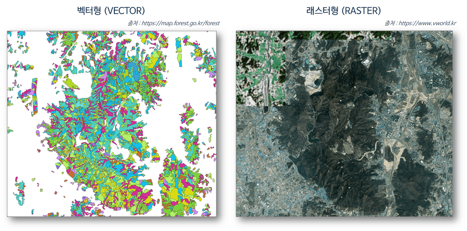
[Example of vector and raster data description]

🟩 Section 2. Vector Layer Analysis and Visualization

Practice basic-intermediate-advanced analysis functions using vector layers

Introduction and practice of attribute tables that can utilize attribute values of data

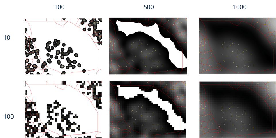
Advanced analysis practice such as K-means clustering, Kernal Density, etc.

Introduction and practice of various visualization concepts using vector layers

[kernel density analysis practice results]

🟦 Section 3. Raster Layer Analysis and Visualization

Practice basic functions such as mosaicking and cropping of raster layers

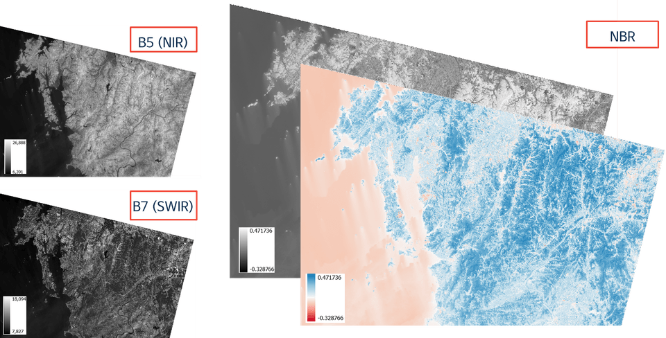
Introduction to downloading USGS satellite images and practice using the raster calculator

Practice of raster data analysis functions linked to vector data

Introduction and practice of visualization concepts using single-band raster layers

[Results of Spectral Index NBR Calculation Practice]

🟥 Section 4. Practical Example 4

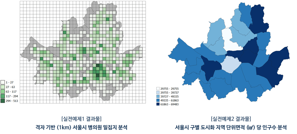
P1. Analysis of the density of hospitals in Seoul based on grid

P2. Analysis of population per unit area of residential area in Seoul

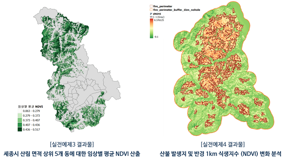
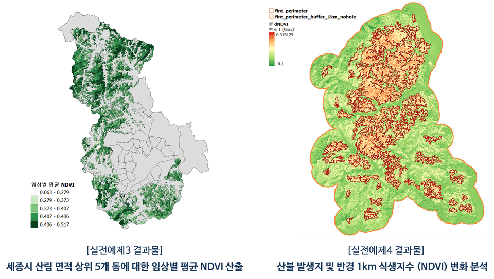
P3. Analysis of average vegetation index by forest area of the top 5 districts in Sejong City

P4. Analysis of vegetation index changes in forest fire occurrence area and 1km radius

[Results of solving practical examples 3 and 4]

Why should I take this course?

The growing importance of GIS

  • Today, it is difficult to find a field where spatial information is not used, and GIS software and its
    Analytics is a key tool in a variety of research, policy, decision-making, and business applications.

  • By learning QGIS , you will improve your ability to apply it widely in various fields ,
    You can also build a competitive career that crosses your major and field of work.

High quality lectures

  • This course is based on many years of experience in GIS education, and is designed so that even those who are new to QGIS can easily follow along . All the materials needed for the course are organized by section and provided at once.

  • The instructor also has published a number of QGIS lectures exclusively on Inflearn, currently reaching over 600 students.
    We provide practical help and plan this course to help you acquire general QGIS usage skills.

Wide range of applications

  • QGIS is a free and powerful open source GIS software for spatial data analysis,
    It offers excellent features for visualization, map making, statistics, and more.

  • After taking the course, you will gain an overall understanding of QGIS and the ability to analyze/visualize it.
    It can be applied to a wide range of fields, including environment, cities, forests, water quality, transportation, and even specific research/analysis projects.

I recommend this to these people.

GIS related work/major

  • UPGRADE my abilities further

  • Maximizing the use of GIS

  • Reduce work/task progress time


Researcher using spatial data

  • Acquire analytical skills through examples

  • Application of more advanced methodology

  • Create a figure to show off your research results

Office worker who dreams of improving his/her specs

  • Linking job fields and GIS

  • Creating new results using GIS

  • New ideas for planning

I also recommend this course to anyone interested in QGIS!!

Embody learning skills through practical examples ( 🟥 Section 4)

Let's make QGIS's features our own through practical examples that use the features we've learned to solve problems.

  • Section 4.4 provides four practical examples to help you apply what you learned in class.

  • Practical examples 1 and 2 utilize vector layers, while problems 3 and 4 are structured around raster layers.

  • As you progress through the problems, the difficulty of the analysis gradually increases, and the number of functions you need to use also increases proportionally.

  • It is composed mainly of functions that are utilized in actual analysis, so it can be usefully applied when carrying out future GIS projects .

Detailed introduction to learning features by section

🟨 Section 1. GIS Basics and QGIS Basic Functions

🟩 Section 2. Vector Layer Analysis and Visualization

🟦 Section 3. Raster Layer Analysis and Visualization

Things to note before taking the class

PC environment

  • QGIS may take different amounts of time depending on the data used, analysis functions, and user PC environment.

  • This lecturer recorded the lecture and practiced the QGIS program on a Windows operating system PC.

Learning Materials

  • All learning materials are based on publicly available materials on the Internet, and students are provided with
    We divide the materials used by section, compress them, and provide them all at once.

  • The source of the data is written in the "source.txt" file in the learning materials compressed file.

Inquiries before/during class

  • For this course, you can ask questions before taking the course and ask QnA during the course.

  • Please leave a question and we will try to answer it as soon as possible :)

FAQ

Is it okay if I just select the parts of the lecture that I need and take them?

Yes, this course covers a wide range of features available in QGIS. Therefore, among the course contents,
Even if you already know some of the material or take only the parts you need, there will be no problem progressing through the course.

Can I directly apply it to the area I am using (work/major/research, etc.)?

Yes, the data used as examples in this lecture is in the format/type of the data you are using.
Although there may be differences, the analysis functions utilized within QGIS are practically the same, so practical use will be possible immediately after the training.

How can I learn more advanced content?

This course covers QGIS in general, and in addition to this course, there are two QGIS courses available exclusively on Inflearn.

Each of them is a hands-on course on QGIS analysis automation using Python and a course focusing on QGIS visualization & layout functions. If you are interested in more advanced analysis methods and visualizations, please also check out the relevant courses below :)

Here are some other QGIS lectures from the instructor 🔗
(Click on the image to go to the lecture page)

cover

[Free] Try QGIS visualization

Cover v2

Curious about QGIS automation?

cover

Curious about QGIS visualization?

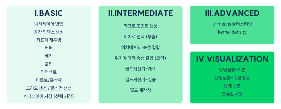
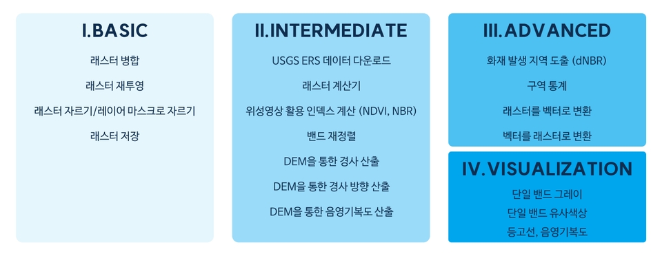
Check out the roadmap divided by topic and difficulty level!!

cover

Roadmap to becoming a QGIS expert

Recommended for
these people

Who is this course right for?

  • GIS User

  • Data user with spatial information

  • People needing GIS analysis and visualization for assignments, research, reports, etc.

  • For those wishing to enhance their work areas and skills

Hello
This is

730

Learners

71

Reviews

56

Answers

4.9

Rating

4

Courses

안녕하세요. GIS/RS를 활용한 분석/연구/강의 전문가 UPWISE 입니다.


기본 정보

  • 서울대학교 환경대학원 석사 학위 취득

  • 서울대학교 환경대학원 박사 과정 수료

  • GIS, Remote Sensing 등 공간자료를 이용한 연구 전공

  • GIS 활용 연구 및 분석 경력 다수

  • 파이썬을 이용한 데이터 분석 및 GIS 자료와 융합 활용한 연구 경력 다수

  • 카카오톡 오픈프로필 https://open.kakao.com/me/upwise (강의, 연구-분석 의뢰 등 문의)


특강 이력

  1. -보고서가 달라지는 데이터 시각화- 데이터 활용 역량강화 교육(2기); 경기도 인재개발원 주관; 2022.12.07. & 09.

  2. 물기업재직자 역량강화 교육 -디지털 프로그램 실습(초급) & Q-GIS 실습(중급); 수자원공사 주관; 2023.06.19.-20.

  3. QGIS 기초 특강; 강사 자체 주관; 2023.10.07-08.

  4. WISE-UP WORKSHOP 도시공간 데이터 분석; 서울대 환경대학원-BK21 스마트시티 사업단 주관; 2024.02.23.

  5. 공공데이터를 활용한 우리 학교 지도 만들기 (동북고등학교); 서울대학교 평생교육원 주관; 2024.05.11.

  6. 공공데이터를 활용한 우리 학교 지도 만들기 (삼성고등학교, 서문여자고등학교); 서울대학교 평생교육원 주관; 2024.07.08. - 10.

  7. 「2024년 물기업 재직자 역량강화」교육 - 디지털 프로그램 실습(기본) - Q-GIS 실습; 수자원공사; 2024.10.02.

  8. 2024년 규제병해충 종합평가회 계획 - QGIS를 활용한 과수화상병 발생 시각화; 충남농업기술원; 2024.10.16.

  9. 데이터분석 전문가 양성 과정; 한국환경공단; 2024.10.25.


  10. 데이터분석 전문가 양성 과정; 한국환경공단; 2025.04.23.


  11. AI를 활용한 빅데이터 분석가 양성 과정; SeSAC; 2025.07.08-16.
Curriculum

All

62 lectures ∙ (10hr 41min)

Course Materials:

Lecture resources
Published: 
Last updated: 

Reviews

All

22 reviews

5.0

22 reviews

  • kfshoi2201님의 프로필 이미지
    kfshoi2201

    Reviews 2

    Average Rating 5.0

    5

    95% enrolled

    거의 모든 기본 기능을 자세히 알려줘서 좋았습니다 최고!!

    • upwise
      Instructor

      Cảm ơn vì những đánh giá hữu ích!! Chúng tôi hy vọng rằng khóa học này sẽ hữu ích với lĩnh vực bạn đang làm việc và nếu bạn có bất kỳ câu hỏi nào liên quan đến khóa học hoặc bất kỳ thắc mắc nào khác, vui lòng liên hệ với chúng tôi. Cảm ơn!! 😀 UPWISE kính chào

  • bglee1044님의 프로필 이미지
    bglee1044

    Reviews 4

    Average Rating 5.0

    5

    100% enrolled

    • upwise
      Instructor

      Cảm ơn bạn đã đánh giá đáng khích lệ của bạn!! Tôi hy vọng bài giảng của tôi sẽ giúp ích rất nhiều cho bạn trong lĩnh vực của bạn. Cảm ơn!! 😀 Giấc mơ TUYỆT VỜI

  • aerolbn님의 프로필 이미지
    aerolbn

    Reviews 27

    Average Rating 5.0

    Edited

    5

    97% enrolled

    Vì là khóa học Qgis hiếm hoi nên rất quý báu và Nội dung bài giảng xuất sắc nên khóa học càng quý hơn. Tôi đã nhận được rất nhiều sự giúp đỡ trong việc sử dụng Qgis. Mong rằng sẽ có thêm nhiều khóa học tốt liên quan đến GIS trong tương lai. =============Đánh giá bổ sung=============== Nội dung bài giảng rất tốt, và đặc biệt là câu trả lời cho các câu hỏi rất tận tâm và nhanh chóng. Thật sự rất nên học.

    • upwise
      Instructor

      Cảm ơn bạn đã đánh giá tuyệt vời. Với tư cách là người tạo khóa học, đây là một sự trợ giúp tuyệt vời!! :) Chúng tôi đặt mục tiêu mở ít nhất một bài giảng mỗi năm và hẹn gặp lại các bạn vào năm sau với một bài giảng hữu ích. Ngoài ra, nếu bạn có bất kỳ câu hỏi nào liên quan đến bài giảng hoặc QGIS, vui lòng liên hệ với chúng tôi bất cứ lúc nào. Cảm ơn!! 😀 Giấc mơ TUYỆT VỜI

  • fallnight님의 프로필 이미지
    fallnight

    Reviews 1

    Average Rating 5.0

    5

    82% enrolled

    Tôi nghĩ nó sẽ hữu ích trong công việc nên nó giúp ích rất nhiều cho việc học QGIS lần đầu tiên. Tôi nên đặt mục tiêu sử dụng mọi chức năng trong bài giảng ít nhất một lần.

    • upwise
      Instructor

      Cảm ơn bạn đã đánh giá đáng khích lệ của bạn!! Tôi hy vọng điều này sẽ giúp ích rất nhiều cho công việc của bạn. Nếu bạn có bất kỳ câu hỏi nào liên quan đến nội dung khóa học hoặc QGIS khi tham gia khóa học, vui lòng liên hệ với chúng tôi. Cảm ơn!! 😀 Giấc mơ TUYỆT VỜI

  • hesse302님의 프로필 이미지
    hesse302

    Reviews 1

    Average Rating 5.0

    5

    31% enrolled

    • upwise
      Instructor

      Chào anh/chị Lee Eun Hee. Cảm ơn anh/chị đã để lại đánh giá khóa học động viên :) UPWISE gửi

Limited time deal ends in 1 days

$2,334,399.00

25%

$114.40

upwise's other courses

Check out other courses by the instructor!

Similar courses

Explore other courses in the same field!