[Free] A Taste of Trendy QGIS Visualization (Presidential Election Map)

Through the visualization of the 20th presidential election results by city, county, and district, you can practically utilize GIS and gain links and insights that can be applied to your major or professional field. This QGIS lecture is designed for beginners to practice the program easily and quickly.

(5.0) 29 reviews

324 learners

Level Beginner

Course period Unlimited

QGIS
QGIS
GIS
GIS
mapping
mapping
data-visualization
data-visualization
trend
trend
QGIS
QGIS
GIS
GIS
mapping
mapping
data-visualization
data-visualization
trend
trend
Thumbnail

Reviews from Early Learners

5.0

5.0

최다니엘

38% enrolled

I'm getting ready to apply for ㅇㅍㄴ in Anyang, a place I really want, and they require this skill! I'll learn hard to make it more my own and apply! Thanks for the good lecture!

5.0

김정윤

38% enrolled

This lecture was like a ray of light for people learning GIS for the first time 😢😢!!

5.0

jaewoong

100% enrolled

It's easy and comfortable. Thank you.

What you will gain after the course

  • QGIS Data Visualization

  • Handling QGIS Data

[Free] Creating Trendy Maps (20th Presidential Election Map Visualization)

#QGIS #GIS #trend #data-visualization #spatial-data #mapping #GISLecture #GISEducation #TheFastestWayToExperienceQGIS

  • In this course, we will use QGIS and public data to create a "Map of the 20th Presidential Election Results by City, County, and District" 🗺

  • Learn how to perform map visualization that reflects trendy issues using free software and data 📰

  • Based on the practice content, we will derive insights that connect to your work, major, or field of expertise 💡

  • This is a free-for-life course, a QGIS lecture designed to help GIS beginners take their first steps 👣

Simple and clear course structure 🪜

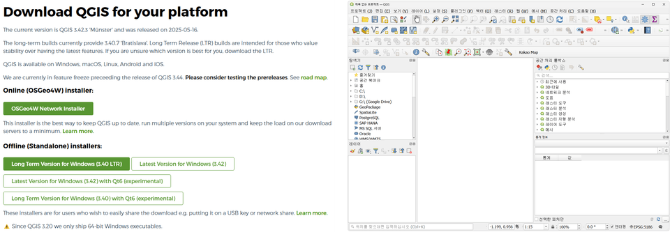
1. Installing and Exploring QGIS

We will install QGIS ourselves, the most actively used free GIS software worldwide, and provide a brief explanation before using the program.

▲ QGIS Installation · Program Interface

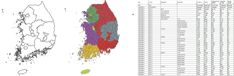
2. Checking Practice Data

We introduce V-World and the Public Data Portal, which are platforms that provide data for free, and we will download and examine the data to be used for the practice in detail.

▲ Vworld · Public Data Portal Practice Data

3. QGIS Visualization Practice

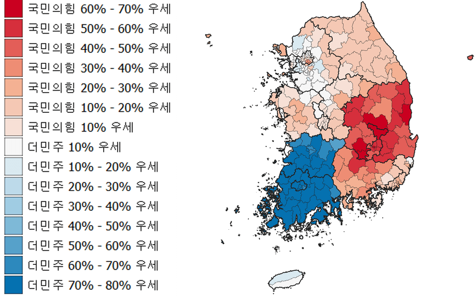
Using the downloaded data, we will visualize the map of the 20th presidential election results by city, county, and district.

In this section, we will conduct actual QGIS practice, which includes exercises on the most frequently used functions such as data joining, symbol visualization, and legend editing.

(The map on the right showing the results of the 20th presidential election is the visualization result of this lecture)

▲ Map of the 20th Presidential Election Results created with QGIS (Visualization Result)

The first free lecture by Inflearn's only QGIS expert knowledge sharer 🥇

  • As an exclusive instructor on Inflearn, I have released a total of three courses, one every year, and I am the only knowledge sharer on Inflearn with specialized expertise in QGIS courses and GIS education.

  • To date, I have provided practical and effective help to over 600 students. I have prepared this free lecture for those who have hesitated to start with GIS, those who are unfamiliar with GIS but want to take on the challenge, and those who wish to enhance their personal professional capabilities.

We created this course for people like you!!

GIS/QGIS Beginners

  • With this free lecture, we have lowered the burden of taking the course, and you can become more familiar with GIS through the use of data closely related to our daily lives.

Personnel in charge of public data utilization tasks

  • We offer new ways to utilize public data for students and professionals who have previously relied solely on Excel.

Those who need a unique skill

  • GIS is a tool used most actively and efficiently across all fields, making it highly suitable for developing your new skills.

In addition to these people, I recommend this course to anyone interested in GIS and map visualization!!

Things to note before taking the course

PC environment

  • QGIS may vary in processing time depending on the data used, analysis functions, and the user's PC environment.

  • The instructor recorded the lectures and conducted the QGIS program practice on a Windows OS PC.

Learning Materials

  • All learning materials utilize public data available on the internet, and we provide students with pre-processed data that is ready for immediate use in practice.

  • The data sources have been documented in the learning material file "출처.txt".

  • You can download the practice and lecture materials in the first lesson.

I would also like to introduce other QGIS courses by the instructor 🔗
(Click the image to go to the course page)

Getting Started with the QGIS Starter Pack

Upgrade Your QGIS Visualization

Learn QGIS Python Automation

Check out our roadmaps categorized by topic and difficulty level!!

QGIS 전문가 학습 로드맵

Instructor Introduction Page: upwise.co.kr

Recommended for
these people

Who is this course right for?

  • Beginners who are unfamiliar with GIS

  • Public data user

  • Those who want to develop unique professional skills

Hello
This is UPWISE

Career Verified

1,098

Learners

113

Reviews

77

Answers

4.9

Rating

4

Courses

Hello. I am UPWISE, an expert in analysis, research, and lecturing using GIS/RS.


Basic Information

  • Master's degree from Seoul National University Graduate School of Environmental Studies

  • Completed doctoral coursework at Seoul National University Graduate School of Environmental Studies

  • Majored in research using spatial data such as GIS and Remote Sensing

  • Extensive experience in GIS-based research and analysis

  • Extensive research experience in data analysis using Python and its integrated application with GIS data.

  • Instructor Introduction Page https://upwise.co.kr/

  • KakaoTalk Open Profile https://open.kakao.com/me/upwise (Inquiries for lectures, research-analysis requests, etc.)


Special Lecture History

  1. -Data Visualization that Transforms Reports- Data Utilization Capability Enhancement Training (2nd Session); Hosted by Gyeonggi-do Human Resources Development Institute; 2022.12.07. & 09.

  2. Competency Enhancement Training for Water Industry Employees - Digital Program Practice (Beginner) & Q-GIS Practice (Intermediate); Hosted by K-water; 2023.06.19.-20.

  3. Basic QGIS Special Lecture; Hosted by the Instructor; 2023.10.07-08.

  4. WISE-UP WORKSHOP Urban Spatial Data Analysis; Hosted by SNU Graduate School of Environmental Studies-BK21 Smart City Project Group; 2024.02.23.

  5. Making Our School Map Using Public Data (Dongbuk High School); Organized by Seoul National University Center for Continuing Education; 2024.05.11.

  6. Creating Our School Map Using Public Data (Samsung High School, Seomun Girls' High School); Hosted by Seoul National University Institute for Continuing Education; 2024.07.08. - 10.

  7. "2024 Water Company Employee Competency Enhancement" Training - Digital Program Practice (Basic) - Q-GIS Practice; K-water; 2024.10.02.

  8. 2024 Comprehensive Evaluation Plan for Regulated Pests - Visualization of Fire Blight Outbreaks Using QGIS; Chungnam Agricultural Research and Extension Services; 2024.10.16.

  9. Data Analysis Expert Training Course; Korea Environment Corporation; 2024.10.25.


  10. Data Analysis Expert Training Course; Korea Environment Corporation; 2025.04.23.


  11. Big Data Analyst Training Course Using AI; SeSAC; 2025.07.08-16.

  12. Understanding GIS and Spatial Analysis Tasks & Data Visualization via DBMS (Basic); Hyundai NGV; 2025.10.23-24.

  13. Understanding GIS and Spatial Analysis via DBMS & Data Visualization (Advanced); Hyundai NGV; 2025.11.10-12.

  14. QGIS Beginner/Intermediate/Advanced Analysis Practice and Visualization; Hanyang Cyber University; 2026.06.20-21.

More
Published: 
Last updated: 

Reviews

All

29 reviews

5.0

29 reviews

  • newtech님의 프로필 이미지
    newtech

    Reviews 6

    Average Rating 5.0

    Edited

    5

    100% enrolled

    Good for beginners.

    • upwise
      Instructor

      Hello Mr. Byeon Yongjin. Thank you for leaving such a wonderful review :) From UPWISE

  • jaewoong8658님의 프로필 이미지
    jaewoong8658

    Reviews 1

    Average Rating 5.0

    5

    100% enrolled

    It's easy and comfortable. Thank you.

    • upwise
      Instructor

      Dear Jaewoong, Thank you for leaving a wonderful course review :) UPWISE

  • gimyuho0664629님의 프로필 이미지
    gimyuho0664629

    Reviews 5

    Average Rating 5.0

    5

    38% enrolled

    I love it so much!!!

    • upwise
      Instructor

      Hello Yuho Kim. Thank you for leaving such an encouraging review :) Best regards, UPWISE

  • wjddbs89446210님의 프로필 이미지
    wjddbs89446210

    Reviews 2

    Average Rating 5.0

    5

    38% enrolled

    This lecture was like a ray of light for people learning GIS for the first time 😢😢!!

    • upwise
      Instructor

      Hello Kim Jeongyoon. Thank you for leaving such an encouraging review. Please look forward to other lectures that will be released in the future :) From UPWISE

  • hanwooljeong3256님의 프로필 이미지
    hanwooljeong3256

    Reviews 1

    Average Rating 5.0

    5

    38% enrolled

    I cannot download the practice data (the administrative district boundary data service has been terminated).

    • upwise
      Instructor

      Hello hanwool.jeong. Thank you for leaving such an encouraging review. Wishing you a happy new year :) From UPWISE

Free