QGIS Beginner All-in-One Starter Pack (Theory/Practice-based)

This is a theory-and-practice QGIS course that covers everything from analysis basics to advanced functions and visualization techniques. Start your QGIS journey with this unprecedented all-in-one course!!

(4.9) 38 reviews

206 learners

Level Beginner

Course period Unlimited

QGIS
QGIS
GIS
GIS
data-visualization
data-visualization
data-analysis
data-analysis
spatial-data
spatial-data
QGIS
QGIS
GIS
GIS
data-visualization
data-visualization
data-analysis
data-analysis
spatial-data
spatial-data

Reviews from Early Learners

4.9

5.0

DONGJIN YEOM

100% enrolled

I work in the forestry sector. I signed up for this course because I felt limited by studying only with QGIS textbooks, and it has been incredibly helpful. The last four practical exercises were challenging, but it was useful to see how various functions are combined and applied. It would be great if you could create a separate course in the future consisting entirely of these types of practical, hands-on problems. Since there is no time limit, I plan to rewatch the lessons frequently until I fully master them. Thank you so much for all the hard work you put into preparing this course!!

5.0

차태영

100% enrolled

The lecture was at a sufficient level for GIS beginners, and it allowed me to learn about each function and application method step by step, which was appropriate for the lecture title. It wasn't just an explanation of the functions, but a 5-explanation + 5-practice format, which made it easy to get the hang of it. Solving appropriate example problems in between helped me understand more. Overall, it was a satisfactory lecture :)

5.0

트레비

55% enrolled

I have always wanted to learn about the entire QGIS function, but it was difficult to find a suitable lecture. This lecture was great because I could learn everything from analysis to visualization by taking just one. Thank you. I look forward to other lectures!!!

What you will gain after the course

  • Basic GIS Concepts and Theory

  • QGIS Vector/Raster/Data Type Analysis

  • QGIS Vector/Raster Visualization

  • Practice of the analysis process using real-world data

There has never been a QGIS course like this before 😲
An all-in-one starter pack to learn both QGIS theory and practice in a single course 🚀

#QGIS #GIS #data-analysis #data-visualization #spatial-data #GIS-lecture #GIS-education #Essential-basics-for-QGIS-beginners

This course is suitable for both QGIS beginners and experienced users,
allowing you to learn basic GIS concepts and theories, QGIS analysis and visualization, and analysis methodologies applying real-world analysis processes.

You can rapidly improve your skills with this all-in-one QGIS course, the likes of which have never been seen before.

This QGIS course consists of 4 main sections, and each section is detailed as follows:
[GIS Basics and QGIS Core Functions, Vector Layer Analysis and Visualization, Raster Layer Analysis and Visualization, 4 Practical Real-world Examples]

Section Introduction

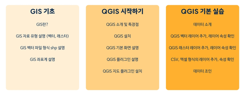
🟨Section 1. GIS Basics and QGIS Core Functions

Learning foundational GIS prerequisite knowledge required before starting the lecture

Learning GIS data types/formats and coordinate system concepts

Introduction to QGIS installation and basic program configuration

Checking attributes for each QGIS input data and practicing basic functions

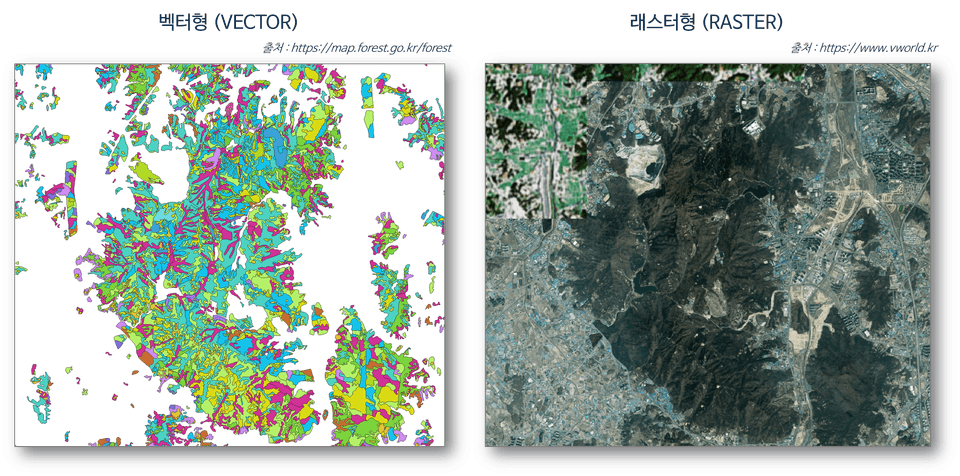
[Examples of explanations for vector and raster data]

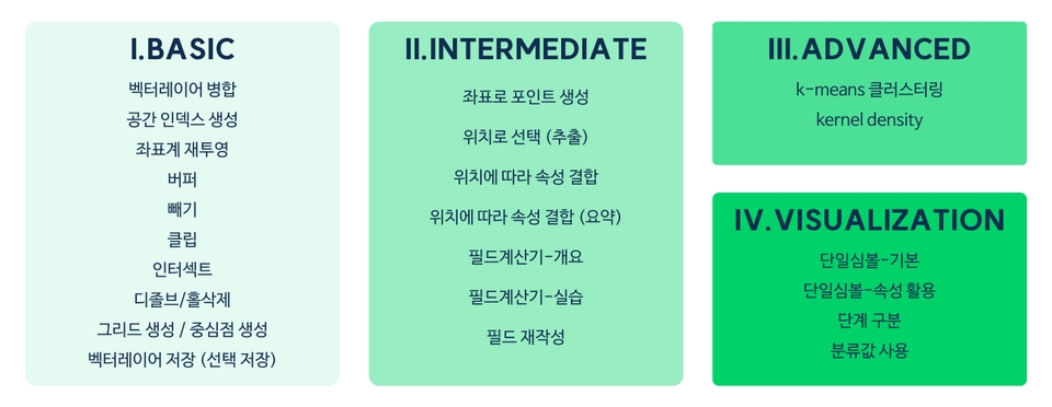
🟩Section 2. Vector Layer Analysis and Visualization

Practice of basic-intermediate-advanced analysis functions using vector layers

Introduction and practice of the attribute table to utilize the attribute values of the data

Advanced analysis practice including K-means clustering and Kernel Density

Introduction and practice of various visualization concepts using vector layers

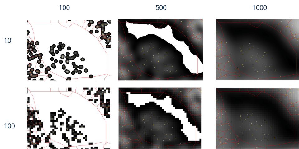
[kernel density analysis practice results]

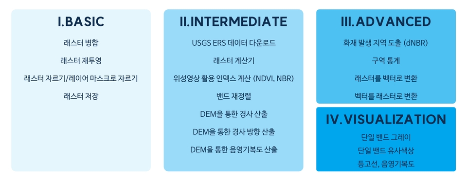
🟦Section 3. Raster Layer Analysis and Visualization

Practice of basic functions for raster layers, such as mosaicking and clipping

Introduction to USGS satellite imagery download methods and Raster Calculator practice

Practice of raster data analysis functions in connection with vector data

Introduction to visualization concepts and hands-on practice using single-band raster layers

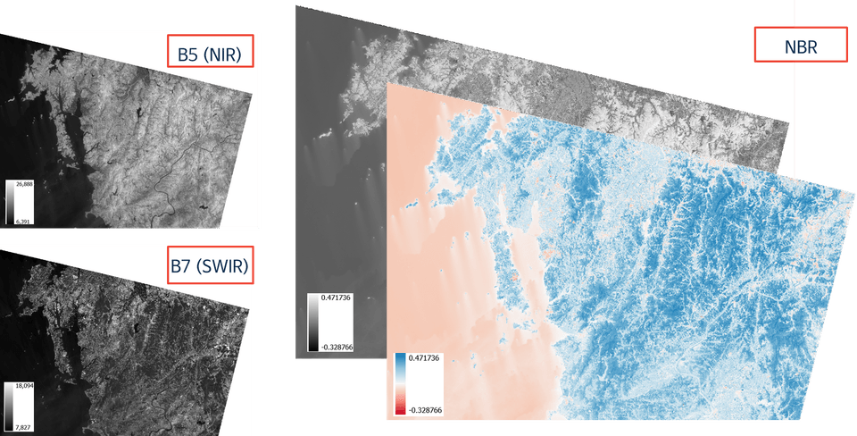
[Spectral Index NBR Calculation Practice Results]

🟥Section 4. Practical Example 4

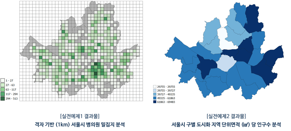
P1. Grid-based analysis of hospital and clinic density in Seoul

P2. Analysis of Population per Unit Area of Residential Zones by District in Seoul

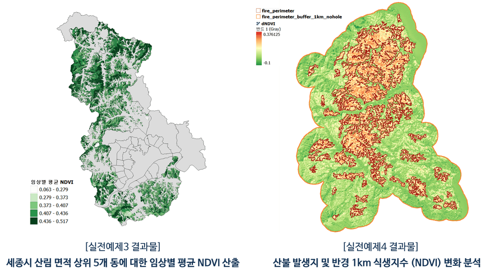
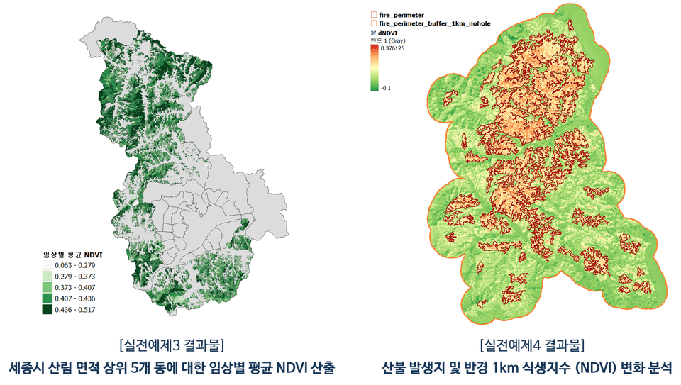
P3. Analysis of average vegetation index by forest type for the top 5 neighborhoods with the largest forest area in Sejong City

P4. Analysis of changes in vegetation index at wildfire sites and within a 1km radius

[Results for Practical Examples 3 and 4]

Why should you take this course?

Increasing Importance of GIS

  • Today, it is difficult to find a field where spatial information is not used, and GIS software and the
    analysis performed through it are being utilized as core tools for various research, policy applications, decision-making, and business.

  • By learning QGIS, you can improve your ability to apply it broadly across various fields and build a competitive career that spans across different majors and professional sectors.

High-quality lectures

  • Based on years of GIS education experience, this course is designed so that even those who are new to QGIS can easily follow along, and all materials required for the course are organized and provided by section.

  • Additionally, the instructor has exclusively released multiple QGIS courses on Inflearn, providing
    practical help to over 600 students, and has designed this course to help learners acquire overall QGIS proficiency.

Wide-ranging Usability

  • QGIS is a free and powerful open-source GIS software that provides excellent features for spatial data analysis,
    visualization, map creation, and statistics.

  • After taking the course, you will be able to understand QGIS as a whole and acquire analysis/visualization skills, which can then be
    applied to various fields including environment, urban planning, forestry, water quality, transportation, and specific research/analysis projects.

Recommended for the following people.

GIS-related professionals/majors

  • UPGRADE my skills even further

  • Maximizing the scope of GIS application

  • Reduce time spent on work/tasks


Spatial data researchers

  • Acquiring analytical skills through examples

  • Applying more advanced methodologies

  • Creating figures to showcase research results

Office workers dreaming of enhancing their specs

  • Connection between job fields and GIS

  • Creating new results using GIS

  • New ideas for planning

I also recommend this course to anyone interested in QGIS!!

Internalizing learned functions through solving practical examples (🟥 Section 4)

Let's make QGIS functions our own through practical exercises where you solve problems yourself using the features you've learned.

  • Through the four practical examples in Section 4, you will actually apply the content practiced during the class.

  • Practical examples 1 and 2 utilize vector layers, while problems 3 and 4 are primarily composed of raster layers.

  • As you progress through the problems, the difficulty of the analysis increases slightly, and the number of functions you need to use increases proportionally.

  • It is composed of functions that are actually used in real-world analysis, so it can be usefully applied when conducting GIS projects in the future.

Detailed introduction of learning functions by section

🟨Section 1. GIS Basics and QGIS Core Functions

🟩Section 2. Vector Layer Analysis and Visualization

🟦Section 3. Raster Layer Analysis and Visualization

Notes before taking the course

PC Environment

  • QGIS processing time may vary depending on the data used, analysis functions, and the user's PC environment.

  • The instructor recorded the lectures and conducted the QGIS software practice on a Windows OS PC.

Learning Materials

  • All learning materials are based on data publicly available on the internet, and for the students,
    the materials used for each section are divided, compressed, and provided all at once.

  • The data sources have been documented in the "출처.txt" file within the learning materials zip file.

Inquiries Before / During the Course

  • Inquiries before taking the course and Q&A during the course are both available.

  • If you leave a question, I will do my best to get back to you as soon as possible :)

FAQ

Is it okay to select and take only the parts of the lecture content that I need?

Yes, this course covers a wide range of functions available in QGIS. Therefore, there is no problem with the course progression even if you already know
some of the content or choose to take only the specific parts you need.

Can I immediately apply this to my specific field (work/major/research, etc.)?

Yes, while the data used as examples in this course may differ in format or type from the materials you are currently using,
the analytical functions utilized within QGIS are essentially the same, so you will be able to apply them practically right after the hands-on practice.

What should I do to learn more advanced content?

This course covers QGIS in general, and two other QGIS courses are exclusively available on Inflearn in addition to this one.

These are lectures focusing on QGIS analysis automation practice using Python and QGIS visualization & layout functions, respectively. If you are interested in more advanced analysis methods and visualization, please check out the corresponding lectures below :)

Introducing other QGIS courses by the instructor 🔗
(Click the image to go to the course page)

[무료] QGIS 트렌디 시각화 찍먹하기 (대선개표지도)

[Free] A Taste of QGIS Visualization

QGIS 파이썬 자동화 (벡터편) Ver.2

Curious about QGIS automation?

QGIS 지도 시각화 A to Z (벡터/기초편)

Curious about QGIS visualization?

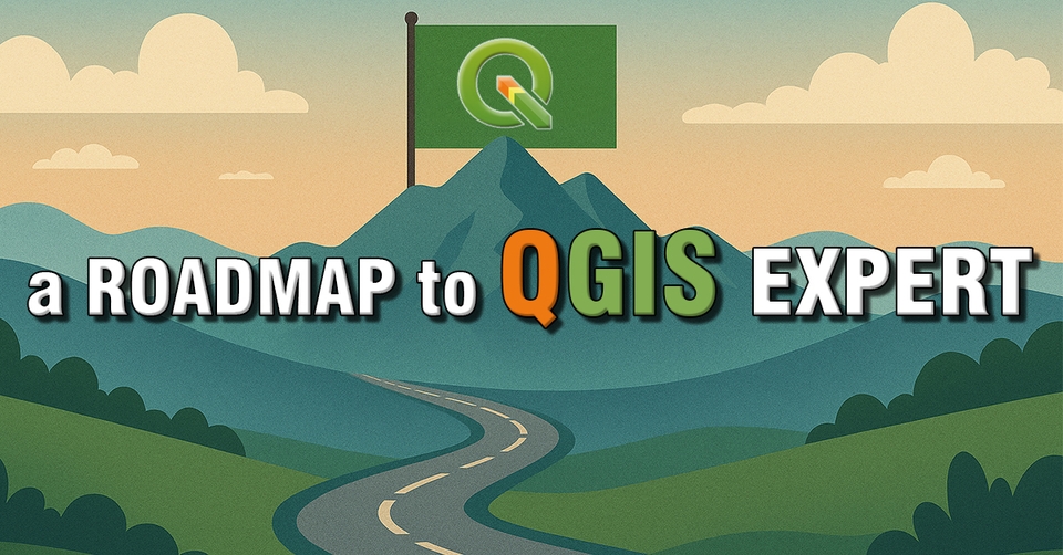
Check out the roadmap, categorized by topic and difficulty level!!

QGIS 전문가 학습 로드맵

Roadmap to becoming a QGIS expert

Instructor Introduction Page: upwise.co.kr

Recommended for
these people

Who is this course right for?

  • GIS User

  • Users of data containing spatial information

  • Those who need GIS analysis and visualization for assignments, research, reports, etc.

  • Those who want to improve their work scope and skills

Hello
This is UPWISE

Career Verified

1,102

Learners

113

Reviews

77

Answers

4.9

Rating

4

Courses

Hello. I am UPWISE, an expert in analysis, research, and lecturing using GIS/RS.


Basic Information

  • Master's degree from Seoul National University Graduate School of Environmental Studies

  • Completed doctoral coursework at Seoul National University Graduate School of Environmental Studies

  • Majored in research using spatial data such as GIS and Remote Sensing

  • Extensive experience in GIS-based research and analysis

  • Extensive research experience in data analysis using Python and its integrated application with GIS data.

  • Instructor Introduction Page https://upwise.co.kr/

  • KakaoTalk Open Profile https://open.kakao.com/me/upwise (Inquiries for lectures, research-analysis requests, etc.)


Special Lecture History

  1. -Data Visualization that Transforms Reports- Data Utilization Capability Enhancement Training (2nd Session); Hosted by Gyeonggi-do Human Resources Development Institute; 2022.12.07. & 09.

  2. Competency Enhancement Training for Water Industry Employees - Digital Program Practice (Beginner) & Q-GIS Practice (Intermediate); Hosted by K-water; 2023.06.19.-20.

  3. Basic QGIS Special Lecture; Hosted by the Instructor; 2023.10.07-08.

  4. WISE-UP WORKSHOP Urban Spatial Data Analysis; Hosted by SNU Graduate School of Environmental Studies-BK21 Smart City Project Group; 2024.02.23.

  5. Making Our School Map Using Public Data (Dongbuk High School); Organized by Seoul National University Center for Continuing Education; 2024.05.11.

  6. Creating Our School Map Using Public Data (Samsung High School, Seomun Girls' High School); Hosted by Seoul National University Institute for Continuing Education; 2024.07.08. - 10.

  7. "2024 Water Company Employee Competency Enhancement" Training - Digital Program Practice (Basic) - Q-GIS Practice; K-water; 2024.10.02.

  8. 2024 Comprehensive Evaluation Plan for Regulated Pests - Visualization of Fire Blight Outbreaks Using QGIS; Chungnam Agricultural Research and Extension Services; 2024.10.16.

  9. Data Analysis Expert Training Course; Korea Environment Corporation; 2024.10.25.


  10. Data Analysis Expert Training Course; Korea Environment Corporation; 2025.04.23.


  11. Big Data Analyst Training Course Using AI; SeSAC; 2025.07.08-16.

  12. Understanding GIS and Spatial Analysis Tasks & Data Visualization via DBMS (Basic); Hyundai NGV; 2025.10.23-24.

  13. Understanding GIS and Spatial Analysis via DBMS & Data Visualization (Advanced); Hyundai NGV; 2025.11.10-12.

  14. QGIS Beginner/Intermediate/Advanced Analysis Practice and Visualization; Hanyang Cyber University; 2026.06.20-21.

More

Curriculum

All

62 lectures ∙ (10hr 41min)

Course Materials:

Lecture resources
Published: 
Last updated: 

Reviews

All

38 reviews

4.9

38 reviews

  • kfshoi2201님의 프로필 이미지
    kfshoi2201

    Reviews 2

    Average Rating 5.0

    5

    95% enrolled

    It was great to have almost all the basic functions explained in detail. The best!!

    • upwise
      Instructor

      Thank you for the encouraging reviews!! I hope it was helpful in your field of work, and if you have any questions about the lecture or other inquiries, please feel free to contact us. Thank you!! 😀 UPWISE Dream

  • aerolbn님의 프로필 이미지
    aerolbn

    Reviews 38

    Average Rating 5.0

    Edited

    5

    97% enrolled

    It is valuable because Qgis lectures are rare, and it is even more valuable because the lecture content is excellent. I received a lot of help with using Qgis. Please continue to provide good lectures related to GIS in the future. =============Additional Review.=============== The lecture content is good, and you also answer questions very sincerely and quickly. I highly recommend it.

    • upwise
      Instructor

      Thank you for the great review. It really helped me as a lecture creator!! :) I aim to open at least one lecture every year, and I will come back next year with another helpful lecture. Also, if you have any questions about the lecture or QGIS, please feel free to contact me anytime. Thank you!! 😀 UPWISE Dream

  • jmhsla73616님의 프로필 이미지
    jmhsla73616

    Reviews 1

    Average Rating 5.0

    5

    31% enrolled

    The QGIS lectures are explained so easily that I am following along without any trouble.

    • upwise
      Instructor

      Hello jmhsla7. Thank you for your encouraging course review :) Best regards, UPWISE

  • fallnight님의 프로필 이미지
    fallnight

    Reviews 1

    Average Rating 5.0

    5

    82% enrolled

    I am learning QGIS for the first time because I think it will be useful for my work. It was very helpful. I think I should try to use all the functions in the lecture at least once.

    • upwise
      Instructor

      Thank you for the helpful course review!! I hope it will be of great help to your work. If you have any questions about the lecture content or QGIS during the course, please feel free to contact me. Thank you!! 😀 UPWISE Dream

  • bglee1044님의 프로필 이미지
    bglee1044

    Reviews 6

    Average Rating 5.0

    5

    100% enrolled

    • upwise
      Instructor

      Thank you for the helpful course review!! I hope my lecture was of great help to you in your field. Thank you!! 😀 UPWISE Dream

Similar courses

Explore other courses in the same field!